
Abomey-Calavi topographic map
Interactive map
Click on the map to display elevation.
About this map
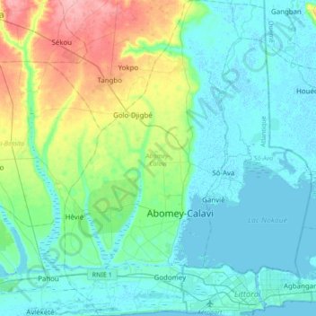
Name: Abomey-Calavi topographic map, elevation, terrain.
Location: Abomey-Calavi, Atlantique Department, Benin (6.34388 2.22964 6.68053 2.44589)
Average elevation: 23 m
Minimum elevation: -3 m
Maximum elevation: 105 m
Other topographic maps
Click on a map to view its topography, its elevation and its terrain.
Djègbadji
Benin > Atlantique Department > Ouidah
Djègbadji, Ouidah, Atlantique Department, Benin
Average elevation: 2 m
Godomey
Benin > Atlantique Department > Abomey-Calavi
Godomey, Abomey-Calavi, Atlantique Department, Benin
Average elevation: 5 m