
Смядово topographic map
Interactive map
Click on the map to display elevation.
About this map
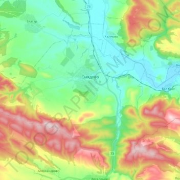
Name: Смядово topographic map, elevation, terrain.
Location: Смядово, Oblast de Choumen, Bulgarie (43.01060 26.88709 43.10038 27.08540)
Average elevation: 216 m
Minimum elevation: 47 m
Maximum elevation: 524 m
Other topographic maps
Click on a map to view its topography, its elevation and its terrain.
Madara
Bulgarie > Oblast de Choumen > Municipalité de Choumen
Madara, Municipalité de Choumen, Oblast de Choumen, 9971, Bulgarie
Average elevation: 190 m
Municipalité de Choumen
Municipalité de Choumen, Oblast de Choumen, Bulgarie
Average elevation: 240 m