
Риш topographic map
Interactive map
Click on the map to display elevation.
About this map
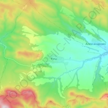
Name: Риш topographic map, elevation, terrain.
Location: Риш, Смядово, Oblast de Choumen, Bulgarie (42.93488 26.86099 43.02843 26.98762)
Average elevation: 374 m
Minimum elevation: 178 m
Maximum elevation: 799 m
Other topographic maps
Click on a map to view its topography, its elevation and its terrain.
Madara
Bulgarie > Oblast de Choumen > Municipalité de Choumen
Madara, Municipalité de Choumen, Oblast de Choumen, 9971, Bulgarie
Average elevation: 190 m
Municipalité de Choumen
Municipalité de Choumen, Oblast de Choumen, Bulgarie
Average elevation: 240 m