
Lifos topographic map
Interactive map
Click on the map to display elevation.
About this map
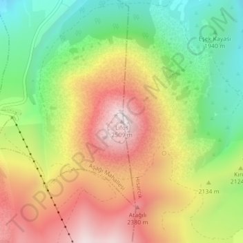
Name: Lifos topographic map, elevation, terrain.
Average elevation: 2,129 m
Minimum elevation: 1,776 m
Maximum elevation: 2,507 m
Other topographic maps
Click on a map to view its topography, its elevation and its terrain.
Mount Erciyes
The climate of the region is influenced by topography, with the Taurus and Kaçkar Mountains blocking the entry of moisture into Anatolia. Summers are dry and hot and winters wet and cold; in Kayseri, summer temperatures are about 19 °C (66 °F) and winter temperature about 0 °C (32 °F). Precipitation at…
Average elevation: 3,329 m