Geolocate

Rule topographic map

Interactive map

Click on the map to display elevation.

About this map

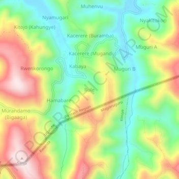
Name: Rule topographic map, elevation, terrain.

Location: Rule, Kabale, Western Region, Uganda (-1.48472 29.92086 -1.44472 29.96086)

Average elevation: 2,164 m

Minimum elevation: 1,961 m

Maximum elevation: 2,439 m

Other topographic maps

Click on a map to view its topography, its elevation and its terrain.

Kengoma

Uganda > Kabale

Kengoma, Kabale, Western Region, Uganda

Average elevation: 1,956 m

Punishment Island (Akampene)

Uganda > Kabale > Murandi

Punishment Island (Akampene), Murandi, Kabale, Western Region, Uganda

Average elevation: 1,951 m

Lake Bunyonyi

Uganda > Kabale > Bufuka

Lake Bunyonyi, Bufuka, Kabale, Western Region, Uganda

Average elevation: 2,047 m

Buhumba

Uganda > Kabale > Buhumba

Buhumba, Kabale, Western Region, Uganda

Average elevation: 2,051 m

Katooma

Uganda > Kabale > Katooma

Katooma, Kabale, Western Region, Uganda

Average elevation: 2,030 m