Geolocate

Escanaba topographic map

Click on the map to display elevation.

About this map

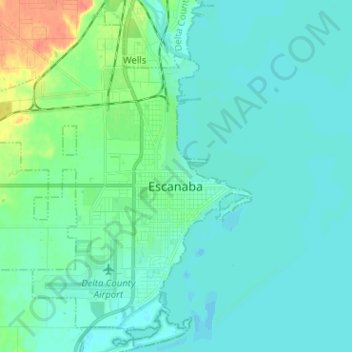
Name: Escanaba topographic map, elevation, terrain.

Location: Escanaba, Delta County, Michigan, 49829, United States (45.70449 -87.16249 45.79176 -87.03721)

Average elevation: 182 m

Minimum elevation: 173 m

Maximum elevation: 223 m

Other topographic maps

Click on a map to view its topography, its elevation and its terrain.

Wells

United States > Michigan > Delta County > Wells Township

Average elevation: 188 m

Lathrop

United States > Michigan > Delta County

Average elevation: 314 m

Rock

United States > Michigan > Delta County

Average elevation: 286 m

Gear up for your next adventure:

🔦Outdoor Torches - Reliable torches for night navigation
🗺️Topographic Maps - Detailed maps showing elevation and terrain features
🔦Head Torches - Hands-free lighting for hiking and camping
🩹Hiking First Aid Kits - Compact medical kits tailored for trail injuries and emergencies
👟Women's Trail Running Shoes - Agile footwear for fell running and technical trails

As an Amazon Associate, this site earns from qualifying purchases at no extra cost to you.