
Usri Nadi topographic map
Interactive map
Click on the map to display elevation.
About this map
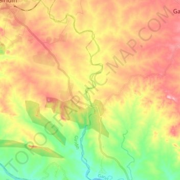
Name: Usri Nadi topographic map, elevation, terrain.
Location: Usri Nadi, Giridih, Jharkhand, 815301, India (24.05983 86.32871 24.18610 86.38210)
Average elevation: 273 m
Minimum elevation: 198 m
Maximum elevation: 345 m
Other topographic maps
Click on a map to view its topography, its elevation and its terrain.
Giridih
Giridih is located at 24°11′N 86°18′E / 24.18°N 86.3°E / 24.18; 86.3. It has an average elevation of 289 metres (948 ft). Śrī Sammed Shikharji also known as the Parasnath Hills, located in Giridih district is the highest mountain peak in Jharkhand. It is a conical granite peak located 4,477…
Average elevation: 292 m