
Kokol topographic map
Interactive map
Click on the map to display elevation.
About this map
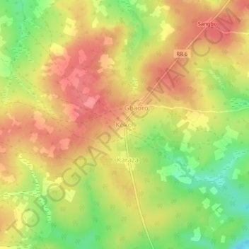
Name: Kokol topographic map, elevation, terrain.
Location: Kokol, Ouham-Pendé, Central African Republic (6.39647 16.32917 6.43647 16.36917)
Average elevation: 673 m
Minimum elevation: 627 m
Maximum elevation: 703 m
Other topographic maps
Click on a map to view its topography, its elevation and its terrain.
Sah
Central African Republic > Ouham-Pendé
Sah, Ouham-Pendé, Central African Republic
Average elevation: 1,226 m
Bang
Central African Republic > Ouham-Pendé > Bang
Bang, Ouham-Pendé, Central African Republic
Average elevation: 607 m
De Gaulle
Central African Republic > Ouham-Pendé > De Gaulle
De Gaulle, Ouham-Pendé, Central African Republic
Average elevation: 1,155 m
Bokaya
Central African Republic > Ouham-Pendé > Bokaya
Bokaya, Ouham-Pendé, Central African Republic
Average elevation: 899 m
Bocaranga
Central African Republic > Ouham-Pendé > Bocaranga
Bocaranga, Ouham-Pendé, Central African Republic
Average elevation: 1,026 m