
Ashby topographic map
Interactive map
Click on the map to display elevation.
About this map
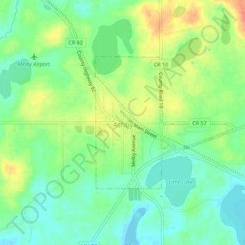
Name: Ashby topographic map, elevation, terrain.
Location: Ashby, Grant County, Minnesota, United States (46.08594 -95.82426 46.10052 -95.80090)
Average elevation: 388 m
Minimum elevation: 368 m
Maximum elevation: 416 m
Other topographic maps
Click on a map to view its topography, its elevation and its terrain.
Wendell
United States > Minnesota > Grant County
Wendell, Grant County, Minnesota, United States
Average elevation: 346 m
Hoffman
United States > Minnesota > Grant County
Hoffman, Grant County, Minnesota, United States
Average elevation: 378 m