
Make a donation
Gear up for your next adventure:
As an Amazon Associate, this site earns from qualifying purchases at no extra cost to you.
Bukit Banang topographic map
Click on the map to display elevation.
Make a donation
Gear up for your next adventure:
As an Amazon Associate, this site earns from qualifying purchases at no extra cost to you.
About this map
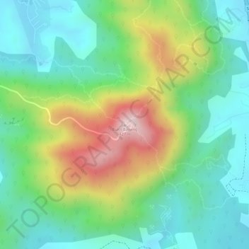
Name: Bukit Banang topographic map, elevation, terrain.
Location: Bukit Banang, Batu Pahat, Johor, 83000, Malaysia (1.81414 102.93980 1.81424 102.93990)
Average elevation: 155 m
Minimum elevation: 14 m
Maximum elevation: 409 m
Make a donation
Gear up for your next adventure:
As an Amazon Associate, this site earns from qualifying purchases at no extra cost to you.
Other topographic maps
Click on a map to view its topography, its elevation and its terrain.
Parit Bukit Batu Pasir
Malaysia > Johor > Batu Pahat > Kampung Bukit Batu Pasir Darat
Average elevation: 5 m
Make a donation
Gear up for your next adventure:
As an Amazon Associate, this site earns from qualifying purchases at no extra cost to you.