Geolocate

Peringode topographic map

Click on the map to display elevation.

About this map

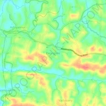
Name: Peringode topographic map, elevation, terrain.

Location: Peringode, Palakkad, Palakkad District, Kerala, 678633, India (10.84239 76.46265 10.88239 76.50265)

Average elevation: 83 m

Minimum elevation: 57 m

Maximum elevation: 118 m

Other topographic maps

Click on a map to view its topography, its elevation and its terrain.

Malampuzha

India > Kerala > Palakkad

Average elevation: 329 m

Gear up for your next adventure:

🌄Compact Monoculars - Lightweight optics for hiking
🧺Ultralight Dry Bags - Organize and waterproof your gear inside your rucksack
🦟Anti-Midge & Tick Repellent - Vital for hiking in the Scottish Highlands during summer
🥾Hiking Boots - Waterproof and durable boots for long-distance hiking in the UK
🧷Tenacious Repair Tape - Instant fix for torn tents, jackets, or dry bags

As an Amazon Associate, this site earns from qualifying purchases at no extra cost to you.