Geolocate

Malampuzha topographic map

Click on the map to display elevation.

About this map

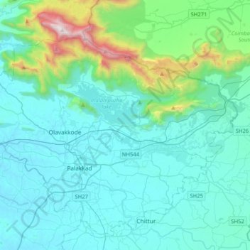
Name: Malampuzha topographic map, elevation, terrain.

Location: Malampuzha, Palakkad, Palakkad District, Kerala, India (10.71362 76.53510 10.93104 76.85385)

Average elevation: 329 m

Minimum elevation: 55 m

Maximum elevation: 2,055 m

Other topographic maps

Click on a map to view its topography, its elevation and its terrain.

Palakkad

India > Kerala > Palakkad

Average elevation: 205 m

Peringode

India > Kerala > Palakkad

Average elevation: 83 m

Kodumbu

India > Kerala > Palakkad

Average elevation: 95 m

Melepuram

India > Kerala > Palakkad > Olavakkode > Melepuram

Average elevation: 84 m

Vadassery

India > Kerala > Palakkad

Average elevation: 89 m

Gear up for your next adventure:

🔦Waterproof LED Headlamps - Hands-free lighting for evening treks and emergency navigation
🕶️Polarized Sunglasses - Reduces glare from snow and water when reading terrain
🛑Emergency Bivvy Bags - Heat-reflective survival bags for unexpected nights out
🧰First Aid Kits - Essential safety kits for outdoor activities
🔋Solar Chargers - Eco-friendly charging solutions for outdoor use

As an Amazon Associate, this site earns from qualifying purchases at no extra cost to you.