
Winthrop topographic map
Click on the map to display elevation.
Winthrop
Winthrop lies at the confluence of the Methow and Chewuch rivers in the Methow Valley. The town is in the eastern foothills of the Cascade Mountains at an elevation of 1,760 feet (540 m). The Okanogan–Wenatchee National Forest and state-managed Methow Wildlife Area surround the Methow Valley.
About this map
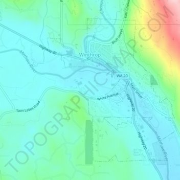
Name: Winthrop topographic map, elevation, terrain.
Average elevation: 567 m
Minimum elevation: 525 m
Maximum elevation: 736 m
Other topographic maps
Click on a map to view its topography, its elevation and its terrain.
Goat Peak
United States > Washington > Okanogan County
Goat Peak is a 7,001-foot (2,134 m) peak in the North Cascades of Washington, United States. The summit offers broad views of the Methow River valley, as well as many of the other prominent cascade peaks including glaciated Silver Star Mountain. A working US Forest Service fire lookout is located on the…
Average elevation: 1,658 m