
Kraljevo topographic map
Interactive map
Click on the map to display elevation.
About this map
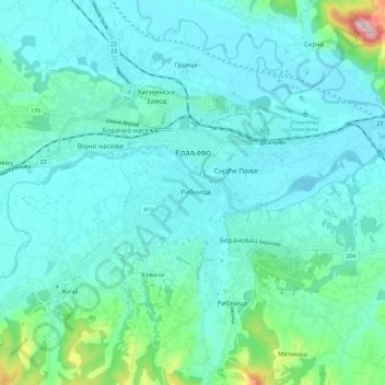
Name: Kraljevo topographic map, elevation, terrain.
Average elevation: 228 m
Minimum elevation: 183 m
Maximum elevation: 490 m
Other topographic maps
Click on a map to view its topography, its elevation and its terrain.
Krusevica
Serbia > Central Serbia > Raska Administrative District > Raska Municipality
Average elevation: 809 m
Stolovi
Serbia > Central Serbia > Raska Administrative District > Kraljevo City
Stolovi (Serbian Cyrillic: Столови) is a mountain in central Serbia, near the city of Kraljevo. Its highest peak Usovica has an elevation of 1,356 meters above sea level.
Average elevation: 1,059 m
Vrnjacka Banja
Serbia > Central Serbia > Raska Administrative District > Vrnjacka Banja Municipality
Average elevation: 286 m
Crna Glava
Serbia > Central Serbia > Raska Administrative District > Raska Municipality
The village is on the Kopaonik mountain range whose average elevation is 1,397 m (4,583 ft). The highest part of the village is Gobelja hill, easily identifiable from Kopaonik by its antenna. It is said that the village has the purest nature in Serbia, boasting clear waters and rare species of birds and…
Average elevation: 1,235 m
Raška
Serbia > Central Serbia > Raska Administrative District > Raska Municipality
Average elevation: 550 m
Maglič
Serbia > Central Serbia > Raska Administrative District > Kraljevo City
Average elevation: 452 m