
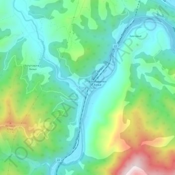
Bogutovac topographic map
Interactive map
Click on the map to display elevation.
About this map
Name: Bogutovac topographic map, elevation, terrain.
Average elevation: 407 m
Minimum elevation: 221 m
Maximum elevation: 875 m
Other topographic maps
Click on a map to view its topography, its elevation and its terrain.
Stanisinci
Serbia > Central Serbia > Raska Administrative District > Vrnjacka Banja Municipality
Average elevation: 797 m
Kravice
Serbia > Central Serbia > Raska Administrative District > Raska Municipality
Average elevation: 597 m
Vrnjacka Banja
Serbia > Central Serbia > Raska Administrative District > Vrnjacka Banja Municipality
Average elevation: 420 m
Lipica
Serbia > Central Serbia > Raska Administrative District > Tutin Municipality
Average elevation: 1,202 m
Tutin
Serbia > Central Serbia > Raska Administrative District > Tutin Municipality
Average elevation: 907 m
Vrnjacka Banja
Serbia > Central Serbia > Raska Administrative District > Vrnjacka Banja Municipality
Average elevation: 420 m
Novi Pazar
Serbia > Central Serbia > Raska Administrative District
Novi Pazar is located in the valleys of the Jošanica, Raška, Deževska, and Ljudska rivers. It lies at an elevation of 496m, in the southeast Raška region. The city is surrounded by the Golija and Rogozna mountains, and the Pešter plateau lies to the west. The total area of the city administrative area is…
Average elevation: 567 m
Vrnjacka Banja Municipality
Serbia > Central Serbia > Raska Administrative District
Average elevation: 540 m
Maglič
Serbia > Central Serbia > Raska Administrative District > Kraljevo City
Average elevation: 452 m