Geolocate

Hart topographic map

Click on the map to display elevation.

About this map

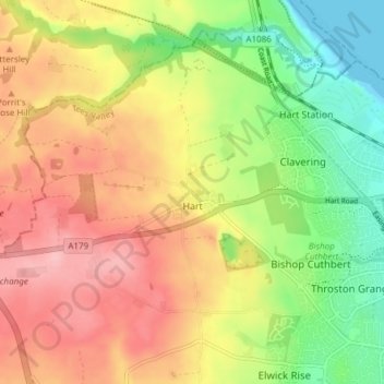
Name: Hart topographic map, elevation, terrain.

Location: Hart, Hartlepool, Tees Valley, England, United Kingdom (54.69023 -1.31423 54.72718 -1.23843)

Average elevation: 70 m

Minimum elevation: -1 m

Maximum elevation: 135 m

Hartlepool trails, hiking, mountain biking, running and outdoor activities

Other topographic maps

Click on a map to view its topography, its elevation and its terrain.

Hartlepool

United Kingdom > England > Hartlepool

Average elevation: 16 m

Teesmouth

United Kingdom > England > Hartlepool

Average elevation: 1 m

Hart Station

United Kingdom > England > Hartlepool

Average elevation: 35 m

Hartlepool

United Kingdom > England > Hartlepool

Average elevation: 16 m

Gear up for your next adventure:

🧼Technical Clothing Wash - Special soap to clean and restore waterproof membranes
🎒Multi-day Trekking Packs - Large capacity backpacks for wild camping and long-distance trails
🥼Base Layers - Thermal base layers for temperature regulation
🔥Emergency Fire Starters - Reliable ignition tools for survival situations in damp conditions
🎒Hiking Child Carriers - Explore the outdoors with the whole family safely

As an Amazon Associate, this site earns from qualifying purchases at no extra cost to you.