Geolocate

Hartlepool topographic map

Click on the map to display elevation.

About this map

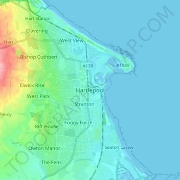
Name: Hartlepool topographic map, elevation, terrain.

Location: Hartlepool, Tees Valley, England, TS24 7EQ, United Kingdom (54.64573 -1.24937 54.72573 -1.16937)

Average elevation: 16 m

Minimum elevation: -2 m

Maximum elevation: 118 m

Hartlepool trails, hiking, mountain biking, running and outdoor activities

Other topographic maps

Click on a map to view its topography, its elevation and its terrain.

Greatham

United Kingdom > England > Hartlepool

[From History, Topography and Directory of Durham, Whellan, London, 1894]

Average elevation: 12 m

Elwick

United Kingdom > England > Hartlepool

Average elevation: 59 m

Wynyard

United Kingdom > England > Hartlepool

Average elevation: 67 m

Hart

United Kingdom > England > Hartlepool

Average elevation: 70 m

Hart

United Kingdom > England > Hartlepool

Average elevation: 70 m

Greatham

United Kingdom > England > Hartlepool

[From History, Topography and Directory of Durham, Whellan, London, 1894]

Average elevation: 12 m

Gear up for your next adventure:

🐕Hiking Dog Harnesses - Rugged harnesses for taking your companion on mountain trails
🎒Hiking Daypacks (20L) - Compact backpacks for day trips and technical mountain ascents
📱Phone Mounts for Hiking - Secure mounts to carry your phone on trails
📷Camera Straps - Secure straps for carrying cameras while walking
👖Packable Overtrousers - Quick-deploy rain protection for legs in sudden storms

As an Amazon Associate, this site earns from qualifying purchases at no extra cost to you.