
Make a donation
Gear up for your next adventure:
As an Amazon Associate, this site earns from qualifying purchases at no extra cost to you.
Sperry topographic map
Click on the map to display elevation.
Make a donation
Gear up for your next adventure:
As an Amazon Associate, this site earns from qualifying purchases at no extra cost to you.
About this map
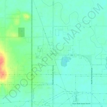
Name: Sperry topographic map, elevation, terrain.
Location: Sperry, Tulsa County, Oklahoma, 74073, United States (36.27731 -96.01139 36.31731 -95.97139)
Average elevation: 191 m
Minimum elevation: 179 m
Maximum elevation: 226 m
Make a donation
Gear up for your next adventure:
As an Amazon Associate, this site earns from qualifying purchases at no extra cost to you.
Other topographic maps
Click on a map to view its topography, its elevation and its terrain.
Make a donation
Gear up for your next adventure:
As an Amazon Associate, this site earns from qualifying purchases at no extra cost to you.
Case Community Park
United States > Oklahoma > Tulsa County > Sand Springs > Shirk
Average elevation: 203 m