
Make a donation
Gear up for your next adventure:
As an Amazon Associate, this site earns from qualifying purchases at no extra cost to you.
Oakhurst topographic map
Click on the map to display elevation.
Make a donation
Gear up for your next adventure:
As an Amazon Associate, this site earns from qualifying purchases at no extra cost to you.
About this map
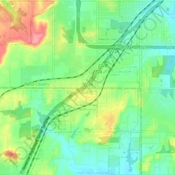
Name: Oakhurst topographic map, elevation, terrain.
Location: Oakhurst, Tulsa County, Oklahoma, United States (36.04663 -96.10099 36.10455 -96.03026)
Average elevation: 228 m
Minimum elevation: 198 m
Maximum elevation: 285 m
Make a donation
Gear up for your next adventure:
As an Amazon Associate, this site earns from qualifying purchases at no extra cost to you.
Other topographic maps
Click on a map to view its topography, its elevation and its terrain.
Make a donation
Gear up for your next adventure:
As an Amazon Associate, this site earns from qualifying purchases at no extra cost to you.
Sand Springs
United States > Oklahoma > Tulsa County > Sand Springs > Sand Springs
Average elevation: 230 m
Case Community Park
United States > Oklahoma > Tulsa County > Sand Springs > Shirk
Average elevation: 203 m