
Make a donation
Gear up for your next adventure:
As an Amazon Associate, this site earns from qualifying purchases at no extra cost to you.
Sucre topographic map
Click on the map to display elevation.
Make a donation
Gear up for your next adventure:
As an Amazon Associate, this site earns from qualifying purchases at no extra cost to you.
About this map
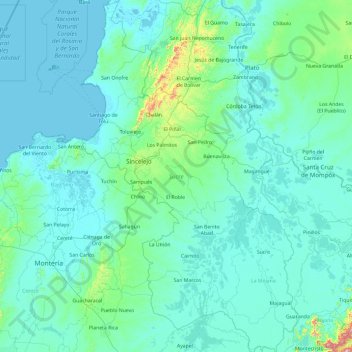
Name: Sucre topographic map, elevation, terrain.
Location: Sucre, 哥伦比亚 / 哥倫比亞 (8.27605 -75.70377 10.14849 -74.53289)
Average elevation: 69 m
Minimum elevation: -2 m
Maximum elevation: 1,550 m
Make a donation
Gear up for your next adventure:
As an Amazon Associate, this site earns from qualifying purchases at no extra cost to you.
Other topographic maps
Click on a map to view its topography, its elevation and its terrain.
辛塞萊霍
哥伦比亚 / 哥倫比亞 > Sucre > Sincelejo
辛塞萊霍(西班牙語:Sincelejo,西班牙语发音:[sinseˈlexo])是哥倫比亞的城市,位於該國北部,也是苏克雷省的省会,距離巴蘭基亞220公里,始建於1776年11月21日,面積为278.4平方公里,海拔高度213米,2016年人口为279,031。
Average elevation: 121 m
Andes
哥伦比亚 / 哥倫比亞 > Antioquia > Andes
安第斯是哥倫比亞的城鎮,位於該國西北部,由安蒂奧基亞省負責管轄,距離首府麥德林121公里,始建於1850年,面積444平方公里,海拔高度1,360米,2011年人口44,278。
Average elevation: 1,559 m
Make a donation
Gear up for your next adventure:
As an Amazon Associate, this site earns from qualifying purchases at no extra cost to you.
Florián
哥伦比亚 / 哥倫比亞 > Santander > Florián
弗洛里安是哥倫比亞的城鎮,位於該國東北部,由桑坦德省負責管轄,距離首府布卡拉曼加300公里,始建於1915年,面積191平方公里,海拔高度1,538米,2005年人口6,273。
Average elevation: 1,571 m
Bello
哥伦比亚 / 哥倫比亞 > Antioquia > Bello
貝約(西班牙語:Bello)是哥倫比亞的城鎮,位於該國中部,由安蒂奧基亞省負責管轄,距離首府麥德林10公里,面積142.35平方公里,海拔高度1,325米,每年平均降雨量1,347毫米,2005年人口371,973。
Average elevation: 1,764 m
Make a donation
Gear up for your next adventure:
As an Amazon Associate, this site earns from qualifying purchases at no extra cost to you.
巴蘭卡韋梅哈
哥伦比亚 / 哥倫比亞 > Santander > Barrancabermeja
巴蘭卡韋梅哈(西班牙語:Barrancabermeja)是哥倫比亞的城市,位於該國東北部馬格達萊納河畔,由桑坦德省負責管轄,距離首府布卡拉曼加110公里,始建於1536年,面積1,154平方公里,海拔高度75米,2010年人口約300,000。
Average elevation: 82 m