
Make a donation
Gear up for your next adventure:
As an Amazon Associate, this site earns from qualifying purchases at no extra cost to you.
Cedar Run topographic map
Click on the map to display elevation.
Make a donation
Gear up for your next adventure:
As an Amazon Associate, this site earns from qualifying purchases at no extra cost to you.
About this map
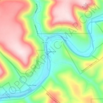
Name: Cedar Run topographic map, elevation, terrain.
Average elevation: 405 m
Minimum elevation: 227 m
Maximum elevation: 623 m
Make a donation
Gear up for your next adventure:
As an Amazon Associate, this site earns from qualifying purchases at no extra cost to you.
Other topographic maps
Click on a map to view its topography, its elevation and its terrain.
Make a donation
Gear up for your next adventure:
As an Amazon Associate, this site earns from qualifying purchases at no extra cost to you.
Cascade Township
United States > Pennsylvania > Lycoming County
According to the United States Census Bureau, the township has a total area of 39.5 square miles (102.4 km2), of which 39.2 square miles (101.5 km2) are land and 0.3 square miles (0.8 km2), or 0.81%, are water. The northern part of the township drains to Pleasant Stream, which flows west to join Lycoming Creek…
Average elevation: 459 m
McHenry Township
United States > Pennsylvania > Lycoming County
According to the United States Census Bureau, the township has a total area of 76.7 square miles (198.6 km2), of which 76.2 square miles (197.4 km2) are land and 0.46 square miles (1.2 km2), or 0.62%, are water. Pine Creek runs through the center of the township at the bottom of Pine Creek Gorge, with creek…
Average elevation: 506 m
Make a donation
Gear up for your next adventure:
As an Amazon Associate, this site earns from qualifying purchases at no extra cost to you.
Make a donation
Gear up for your next adventure:
As an Amazon Associate, this site earns from qualifying purchases at no extra cost to you.
Cascade Township
United States > Pennsylvania > Lycoming County
According to the United States Census Bureau, the township has a total area of 39.5 square miles (102.4 km2), of which 39.2 square miles (101.5 km2) are land and 0.3 square miles (0.8 km2), or 0.81%, are water. The northern part of the township drains to Pleasant Stream, which flows west to join Lycoming Creek…
Average elevation: 459 m
Make a donation
Gear up for your next adventure:
As an Amazon Associate, this site earns from qualifying purchases at no extra cost to you.
Make a donation
Gear up for your next adventure:
As an Amazon Associate, this site earns from qualifying purchases at no extra cost to you.