
Muncy Township topographic map
Interactive map
Click on the map to display elevation.
About this map
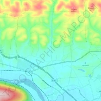
Name: Muncy Township topographic map, elevation, terrain.
Location: Muncy Township, Lycoming County, Pennsylvania, United States (41.22077 -76.84996 41.28198 -76.74677)
Average elevation: 229 m
Minimum elevation: 140 m
Maximum elevation: 480 m
Other topographic maps
Click on a map to view its topography, its elevation and its terrain.
Elimsport
United States > Pennsylvania > Lycoming County > Washington Township
Average elevation: 192 m
Cove Mountain
United States > Pennsylvania > Lycoming County > Gamble Township
Average elevation: 426 m
Cogan Station
United States > Pennsylvania > Lycoming County > Hepburn Township
Average elevation: 242 m
Raccoon Mountain
United States > Pennsylvania > Lycoming County > Armstrong Township
Average elevation: 379 m
Waterville
United States > Pennsylvania > Lycoming County > Cummings Township
Average elevation: 388 m