
Mount Tabor topographic map
Interactive map
Click on the map to display elevation.
About this map
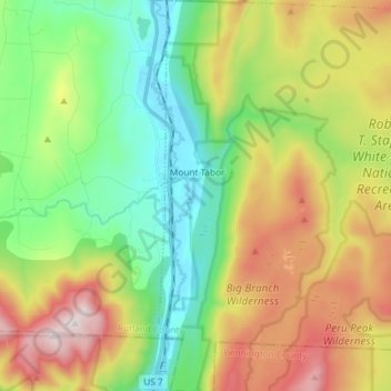
Name: Mount Tabor topographic map, elevation, terrain.
Location: Mount Tabor, Rutland County, Vermont, United States (43.29055 -72.99684 43.39766 -72.85352)
Average elevation: 548 m
Minimum elevation: 190 m
Maximum elevation: 1,141 m
Other topographic maps
Click on a map to view its topography, its elevation and its terrain.
Billings Mobile Manor
United States > Vermont > Rutland County > Rutland City
Average elevation: 211 m
West Tinmouth
United States > Vermont > Rutland County > Tinmouth > West Tinmouth
Average elevation: 419 m