
Make a donation
Gear up for your next adventure:
As an Amazon Associate, this site earns from qualifying purchases at no extra cost to you.
Choibalsan topographic map
Click on the map to display elevation.
Make a donation
Gear up for your next adventure:
As an Amazon Associate, this site earns from qualifying purchases at no extra cost to you.
About this map
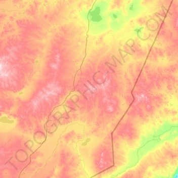
Name: Choibalsan topographic map, elevation, terrain.
Location: Choibalsan, Dornod, Mongolia (48.14501 114.44358 49.63576 116.48231)
Average elevation: 725 m
Minimum elevation: 499 m
Maximum elevation: 1,041 m
Make a donation
Gear up for your next adventure:
As an Amazon Associate, this site earns from qualifying purchases at no extra cost to you.
Other topographic maps
Click on a map to view its topography, its elevation and its terrain.
Choibalsan
Choibalsan (Mongolian: Чойбалсан) is the fourth-largest city in Mongolia after Ulaanbaatar, Darkhan, and Erdenet. The name of the city was Bayan Tümen (Баян Түмэн) until 1941, when it was renamed after the communist leader Khorloogiin Choibalsan in honor of the 20th anniversary of the…
Average elevation: 764 m
Make a donation
Gear up for your next adventure:
As an Amazon Associate, this site earns from qualifying purchases at no extra cost to you.