
Val-d'Illiez topographic map
Interactive map
Click on the map to display elevation.
About this map
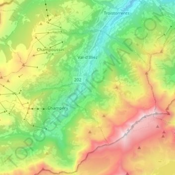
Name: Val-d'Illiez topographic map, elevation, terrain.
Location: Val-d'Illiez, Monthey, Wallis, 1873, Switzerland (46.15516 6.80699 46.21897 6.94807)
Average elevation: 1,672 m
Minimum elevation: 649 m
Maximum elevation: 3,247 m
Other topographic maps
Click on a map to view its topography, its elevation and its terrain.
Champéry
Switzerland > Wallis > Monthey
The Champéry – Planachaux cable-car (125 passengers) and the new 6 seater chairlift in Grand-Paradis takes skiers to the Portes du Soleil recreational area, at an altitude of 2,000 m (6,600 ft). With 194 ski lifts and over 650 km (400 mi) of ski slopes, this is the largest international ski area in the world.
Average elevation: 1,883 m