
Troistorrents topographic map
Interactive map
Click on the map to display elevation.
About this map
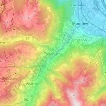
Name: Troistorrents topographic map, elevation, terrain.
Location: Troistorrents, Monthey, Wallis, Switzerland (46.19876 6.82059 46.25929 6.94397)
Average elevation: 1,231 m
Minimum elevation: 389 m
Maximum elevation: 2,281 m
Other topographic maps
Click on a map to view its topography, its elevation and its terrain.
Val-d'Illiez
Switzerland > Wallis > Monthey
Val-d'Illiez, Monthey, Wallis, 1873, Switzerland
Average elevation: 1,672 m
Lac de Taney
Switzerland > Wallis > Monthey > Vouvry > Taney
Lac de Taney, Taney, Vouvry, Monthey, Wallis, 1896, Switzerland
Average elevation: 1,430 m
Champéry
Switzerland > Wallis > Monthey
Champéry, Monthey, Wallis, 1874, Switzerland
Average elevation: 1,883 m
Saint-Gingolph
Switzerland > Wallis > Monthey > Saint-Gingolph
Saint-Gingolph, Monthey, Wallis, 1898, Switzerland
Average elevation: 1,104 m