
Gardelegen topographic map
Interactive map
Click on the map to display elevation.
About this map
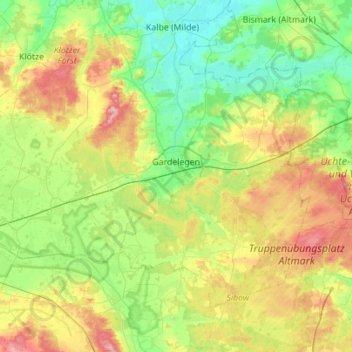
Name: Gardelegen topographic map, elevation, terrain.
Location: Gardelegen, Altmarkkreis Salzwedel, Saxony-Anhalt, Germany (52.38672 11.05106 52.63852 11.60532)
Average elevation: 68 m
Minimum elevation: 28 m
Maximum elevation: 150 m
Other topographic maps
Click on a map to view its topography, its elevation and its terrain.
Milde
Germany > Saxony-Anhalt > Altmarkkreis Salzwedel
Milde, Altmarkkreis Salzwedel, Saxony-Anhalt, Germany
Average elevation: 59 m
Breitenfeld
Germany > Saxony-Anhalt > Altmarkkreis Salzwedel > Gardelegen
Breitenfeld, Gardelegen, Altmarkkreis Salzwedel, Saxony-Anhalt, Germany
Average elevation: 84 m
Salzwedel
Germany > Saxony-Anhalt > Altmarkkreis Salzwedel
Salzwedel, Altmarkkreis Salzwedel, Saxony-Anhalt, 29410, Germany
Average elevation: 25 m