
Tolè topographic map
Click on the map to display elevation.
About this map
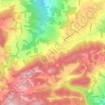
Name: Tolè topographic map, elevation, terrain.
Average elevation: 665 m
Minimum elevation: 394 m
Maximum elevation: 851 m
Other topographic maps
Click on a map to view its topography, its elevation and its terrain.
Bologna
Italy > Emilia-Romagna > Bologna
Bologna is situated on the edge of the Po Plain at the foot of the Apennine Mountains, at the meeting of the Reno and Savena river valleys. As Bologna's two main watercourses flow directly to the sea, the town lies outside of the drainage basin of the River Po. The Province of Bologna stretches from the…
Average elevation: 91 m
Bologna
Italy > Emilia-Romagna > Bologna
Bologna is situated on the edge of the Po Plain at the foot of the Apennine Mountains, at the meeting of the Reno and Savena river valleys. As Bologna's two main watercourses flow directly to the sea, the town lies outside of the drainage basin of the River Po. The province of Bologna stretches from the…
Average elevation: 91 m
Bologna
Italy > Emilia-Romagna > Bologna
Bologna is situated on the edge of the Po Plain at the foot of the Apennine Mountains, at the meeting of the Reno and Savena river valleys. As Bologna's two main watercourses flow directly to the sea, the town lies outside of the drainage basin of the River Po. The Province of Bologna stretches from the…
Average elevation: 91 m
Bologna
Italy > Emilia-Romagna > Bologna
Bologna is situated on the edge of the Po Plain at the foot of the Apennine Mountains, at the meeting of the Reno and Savena river valleys. As Bologna's two main watercourses flow directly to the sea, the town lies outside of the drainage basin of the River Po. The province of Bologna stretches from the…
Average elevation: 91 m
Monghidoro
Italy > Emilia-Romagna > Bologna
The territory surrounding the municipality is, for the largest part, mountainous with elevations ranging between a minimum of 400 metres (1,300 ft) above sea level to the north-east to a maximum of 1,290 metres (4,230 ft) on its southern flank.
Average elevation: 732 m
Bologna
Italy > Emilia-Romagna > Bologna
Bologna is situated on the edge of the Po Plain at the foot of the Apennine Mountains, at the meeting of the Reno and Savena river valleys. As Bologna's two main watercourses flow directly to the sea, the town lies outside of the drainage basin of the River Po. The Province of Bologna stretches from the…
Average elevation: 91 m