
Vardenis community topographic map
Interactive map
Click on the map to display elevation.
About this map
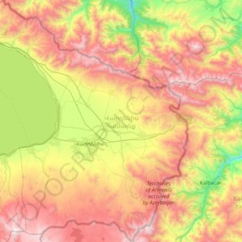
Name: Vardenis community topographic map, elevation, terrain.
Location: Vardenis community, Gegharkunik Province, Armenia (39.99006 45.43810 40.46455 45.97991)
Average elevation: 2,284 m
Minimum elevation: 1,274 m
Maximum elevation: 3,503 m
Other topographic maps
Click on a map to view its topography, its elevation and its terrain.
Lake Sevan
Armenia > Gegharkunik Province
Lake Sevan (Armenian: Սևանա լիճ, romanized: Sevana lich) is the largest body of water in both Armenia and the Caucasus region. It is one of the largest freshwater high-altitude (alpine) lakes in Eurasia. The lake is situated in Gegharkunik Province, at an altitude of 1,900 m (6,234 ft) above sea level.…
Average elevation: 2,025 m