
Lake Sevan topographic map
Interactive map
Click on the map to display elevation.
Lake Sevan
Lake Sevan (Armenian: Սևանա լիճ, romanized: Sevana lich) is the largest body of water in both Armenia and the Caucasus region. It is one of the largest freshwater high-altitude (alpine) lakes in Eurasia. The lake is situated in Gegharkunik Province, at an altitude of 1,900 m (6,234 ft) above sea level. The total surface area of its basin is about 5,000 km2 (1,900 sq mi), which makes up 1⁄6 of Armenia's territory. The lake itself is 1,242 km2 (480 sq mi), and the volume is 32.8 km3 (7.9 cu mi). It is fed by 28 rivers and streams. Only 10% of the incoming water is drained by the Hrazdan River, while the remaining 90% evaporates.
About this map
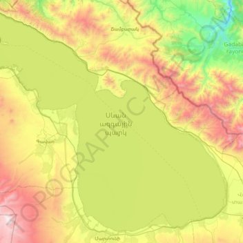
Name: Lake Sevan topographic map, elevation, terrain.
Location: Lake Sevan, Gegharkunik Province, Armenia (40.15289 44.94790 40.63202 45.64481)
Average elevation: 2,025 m
Minimum elevation: 1,116 m
Maximum elevation: 3,547 m
Other topographic maps
Click on a map to view its topography, its elevation and its terrain.