
Make a donation
Gear up for your next adventure:
As an Amazon Associate, this site earns from qualifying purchases at no extra cost to you.
Hodapp Marsh topographic map
Click on the map to display elevation.
Make a donation
Gear up for your next adventure:
As an Amazon Associate, this site earns from qualifying purchases at no extra cost to you.
About this map
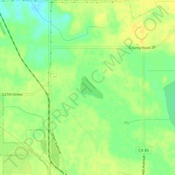
Name: Hodapp Marsh topographic map, elevation, terrain.
Location: Hodapp Marsh, Blue Earth County, Minnesota, United States (44.19544 -93.92260 44.19896 -93.91751)
Average elevation: 306 m
Minimum elevation: 292 m
Maximum elevation: 315 m
Make a donation
Gear up for your next adventure:
As an Amazon Associate, this site earns from qualifying purchases at no extra cost to you.
Other topographic maps
Click on a map to view its topography, its elevation and its terrain.
Make a donation
Gear up for your next adventure:
As an Amazon Associate, this site earns from qualifying purchases at no extra cost to you.
Skyline
United States > Minnesota > Blue Earth County
According to the U.S. Census Bureau, the city has a total area of 0.17 square miles (0.44 km2), all land. Its elevation is 980 feet (300 m) above sea-level.
Average elevation: 265 m
Make a donation
Gear up for your next adventure:
As an Amazon Associate, this site earns from qualifying purchases at no extra cost to you.
Make a donation
Gear up for your next adventure:
As an Amazon Associate, this site earns from qualifying purchases at no extra cost to you.