Geolocate

Ferndale topographic map

Click on the map to display elevation.

About this map

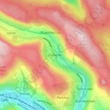
Name: Ferndale topographic map, elevation, terrain.

Location: Ferndale, Rhondda Cynon Taf, Wales, CF43 4EW, United Kingdom (51.64043 -3.46701 51.68043 -3.42701)

Average elevation: 330 m

Minimum elevation: 139 m

Maximum elevation: 473 m

Rhondda Cynon Taf trails, hiking, mountain biking, running and outdoor activities

Other topographic maps

Click on a map to view its topography, its elevation and its terrain.

Mid Glamorgan

United Kingdom > Wales > Rhondda Cynon Taf

Average elevation: 235 m

Pontypridd

United Kingdom > Wales > Rhondda Cynon Taf

Average elevation: 183 m

Penrhiwceiber

United Kingdom > Wales > Rhondda Cynon Taf

Average elevation: 229 m

Pontypridd

United Kingdom > Wales > Rhondda Cynon Taf

Average elevation: 183 m

Trealaw

United Kingdom > Wales > Rhondda Cynon Taf > Tonypandy

Average elevation: 222 m

Gear up for your next adventure:

🌄Compact Monoculars - Lightweight optics for hiking
🛌Sleeping Mats - Insulated mats for comfortable outdoor sleeping
🥫Expedition Meals - Lightweight, high-calorie nutrition for long-distance hikers
🩹Hiking First Aid Kits - Compact medical kits tailored for trail injuries and emergencies
📱Rugged Phone Cases - Heavy-duty protection for smartphones used as secondary GPS tools

As an Amazon Associate, this site earns from qualifying purchases at no extra cost to you.