
Higashiosaka topographic map
Click on the map to display elevation.
About this map
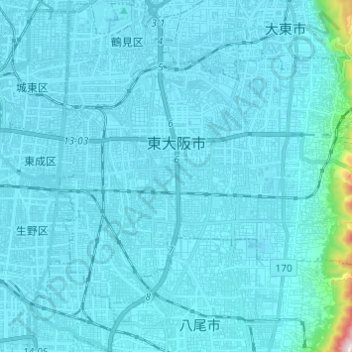
Name: Higashiosaka topographic map, elevation, terrain.
Location: Higashiosaka, Osaka Prefecture, Japan (34.63219 135.55704 34.70425 135.67905)
Average elevation: 22 m
Minimum elevation: 0 m
Maximum elevation: 456 m
Other topographic maps
Click on a map to view its topography, its elevation and its terrain.
Mt. Yamato-Katsuragi
Japan > Osaka Prefecture > Minamikawachi County > Chihaya-akasaka
Mount Yamato Katsuragi (大和葛城山, Yamato Katsuragi-san) or simply Mount Katsuragi is a mountain in the Kongō Range straddling the prefectural border between Chihayaakasaka, Osaka and Gose, Nara in Japan. The peak elevation is 959.2 metres (3,147 ft). The mountain is located along the Gose Line of the…
Average elevation: 653 m