
East Honolulu topographic map
Interactive map
Click on the map to display elevation.
About this map
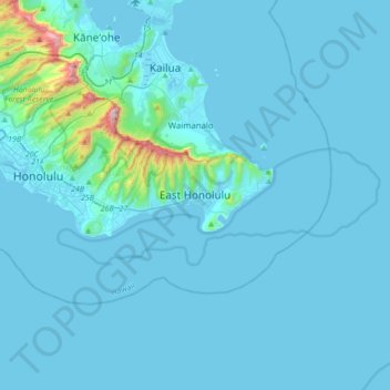
Name: East Honolulu topographic map, elevation, terrain.
Average elevation: 50 m
Minimum elevation: -3 m
Maximum elevation: 928 m
Other topographic maps
Click on a map to view its topography, its elevation and its terrain.
Oʻahu
United States > Hawaii > Honolulu County
Oʻahu exhibits a striking and diverse topography shaped primarily by its volcanic origins and subsequent erosion. The island features a rugged landscape dominated by two prominent volcanic mountains, Koʻolau and Waiʻanae, which rise sharply from the coastline, reaching elevations of approximately 4,000…
Average elevation: 79 m
Pearl Harbor National Memorial
United States > Hawaii > Honolulu County > Waipahu
Average elevation: 9 m
Waimānalo Beach Park
United States > Hawaii > Honolulu County > East Honolulu > Waimanalo
Average elevation: 55 m
Lisianski Island
United States > Hawaii > Honolulu County
Lisianski Island (Hawaiian: Papa‘āpoho) is one of the Northwestern Hawaiian Islands, with a land area of 384.425 acres (155.571 ha) and a maximum elevation of 40 feet (12 m) above sea level. It is a low, flat sand and coral island about 905 nautical miles (1,676 km) northwest of Honolulu. The island is…
Average elevation: 1 m