
Cerro Negro topographic map
Interactive map
Click on the map to display elevation.
About this map
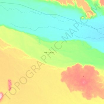
Name: Cerro Negro topographic map, elevation, terrain.
Location: Cerro Negro, Deseado, SC, Argentinien (-47.15672 -67.96495 -47.06320 -67.72465)
Average elevation: 183 m
Minimum elevation: 110 m
Maximum elevation: 308 m
Other topographic maps
Click on a map to view its topography, its elevation and its terrain.
Forestal
Argentinien > SC > Río Gallegos
Forestal, Río Gallegos, Güer Aike, SC, Argentinien
Average elevation: 14 m
Cerro Catedral
Cerro Catedral, Lago Argentino, SC, Argentinien
Average elevation: 829 m
Macrozona Lago Argentino
Macrozona Lago Argentino, El Calafate, Lago Argentino, SC, Argentinien
Average elevation: 201 m