Geolocate

Green Township topographic map

Interactive map

Click on the map to display elevation.

About this map

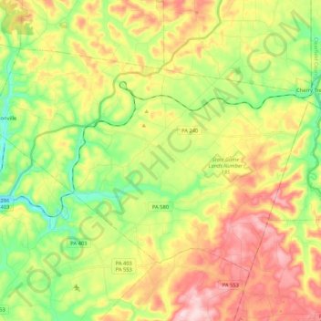
Name: Green Township topographic map, elevation, terrain.

Location: Green Township, Indiana County, Pennsylvania, United States (40.63564 -79.01880 40.74682 -78.80811)

Average elevation: 495 m

Minimum elevation: 372 m

Maximum elevation: 647 m

Other topographic maps

Click on a map to view its topography, its elevation and its terrain.

Creekside

United States > Pennsylvania > Indiana County

Creekside, Indiana County, Pennsylvania, United States

Average elevation: 360 m

Center Township

United States > Pennsylvania > Indiana County

Center Township, Indiana County, Pennsylvania, United States

Average elevation: 390 m

Clymer

United States > Pennsylvania > Indiana County

Clymer, Indiana County, Pennsylvania, United States

Average elevation: 443 m

Coy Junction

United States > Pennsylvania > Indiana County > Homer City

Coy Junction, Homer City, Indiana County, Pennsylvania, 15748, United States

Average elevation: 368 m

Indiana

United States > Pennsylvania > Indiana County > Indiana

Indiana, Indiana County, Pennsylvania, United States

Average elevation: 407 m