Center Township topographic map
Interactive map
Click on the map to display elevation.
About this map
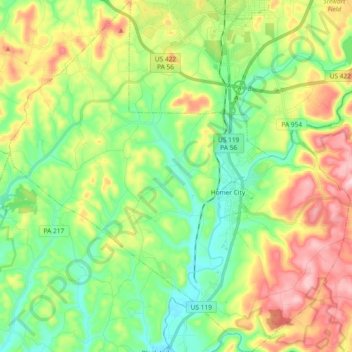
Name: Center Township topographic map, elevation, terrain.
Location: Center Township, Indiana County, Pennsylvania, United States (40.47968 -79.27696 40.61979 -79.09788)
Average elevation: 390 m
Minimum elevation: 292 m
Maximum elevation: 558 m
Other topographic maps
Click on a map to view its topography, its elevation and its terrain.
Creekside
United States > Pennsylvania > Indiana County
Creekside, Indiana County, Pennsylvania, United States
Average elevation: 360 m
Clymer
United States > Pennsylvania > Indiana County
Clymer, Indiana County, Pennsylvania, United States
Average elevation: 443 m
Green Township
United States > Pennsylvania > Indiana County
Green Township, Indiana County, Pennsylvania, United States
Average elevation: 495 m
Coy Junction
United States > Pennsylvania > Indiana County > Homer City
Coy Junction, Homer City, Indiana County, Pennsylvania, 15748, United States
Average elevation: 368 m
Indiana
United States > Pennsylvania > Indiana County > Indiana
Indiana, Indiana County, Pennsylvania, United States
Average elevation: 407 m