
Peterberg topographic map
Interactive map
Click on the map to display elevation.
About this map
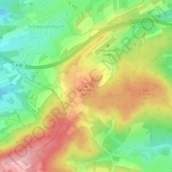
Name: Peterberg topographic map, elevation, terrain.
Average elevation: 490 m
Minimum elevation: 409 m
Maximum elevation: 583 m
Other topographic maps
Click on a map to view its topography, its elevation and its terrain.
Diegelsberg
Deutschland > Saarland > Nohfelden
Diegelsberg, Nohfelden, Landkreis St. Wendel, Saarland, Deutschland
Average elevation: 469 m
Sötern
Deutschland > Saarland > Nohfelden
Sötern, Nohfelden, Landkreis St. Wendel, Saarland, Deutschland
Average elevation: 481 m
Türkismühle
Deutschland > Saarland > Nohfelden
Türkismühle, Nohfelden, Landkreis St. Wendel, Saarland, Deutschland
Average elevation: 413 m