
Aiguá topographic map
Interactive map
Click on the map to display elevation.
Aiguá
The municipality of Aiguá has the highest point of Uruguay, the Cerro Catedral. This point is situated at an altitude of 513.66 metres (1,685.2 ft).
About this map
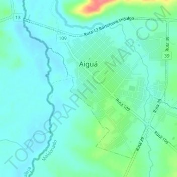
Name: Aiguá topographic map, elevation, terrain.
Location: Aiguá, Maldonado, 20500, Uruguay (-34.21644 -54.77915 -34.19507 -54.74746)
Average elevation: 95 m
Minimum elevation: 81 m
Maximum elevation: 147 m
Other topographic maps
Click on a map to view its topography, its elevation and its terrain.
Cerro Catedral
Cerro Catedral ("Cathedral Hill"), also known as Cerro Cordillera, is a peak and the highest point of Uruguay, with an altitude of 513.66 m (1,685.2 ft). It is located north of Maldonado Department, in the municipality of Aiguá, in a hill range named Sierra Carapé, which constitutes part of a larger range…
Average elevation: 415 m