
Chittenden topographic map
Interactive map
Click on the map to display elevation.
About this map
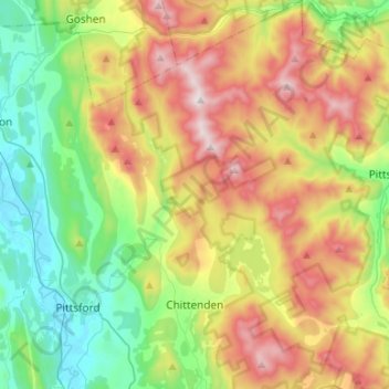
Name: Chittenden topographic map, elevation, terrain.
Location: Chittenden, Rutland County, Vermont, 05737, United States (43.66571 -73.01709 43.85806 -72.82608)
Average elevation: 473 m
Minimum elevation: 102 m
Maximum elevation: 1,063 m
Other topographic maps
Click on a map to view its topography, its elevation and its terrain.
Billings Mobile Manor
United States > Vermont > Rutland County > Rutland City
Average elevation: 211 m
West Tinmouth
United States > Vermont > Rutland County > Tinmouth > West Tinmouth
Average elevation: 419 m