
North Crawley topographic map
Interactive map
Click on the map to display elevation.
About this map
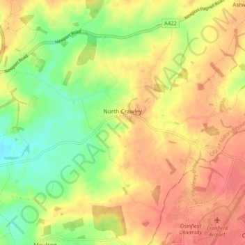
Name: North Crawley topographic map, elevation, terrain.
Location: North Crawley, City of Milton Keynes, England, United Kingdom (52.07360 -0.67681 52.10978 -0.59677)
Average elevation: 89 m
Minimum elevation: 57 m
Maximum elevation: 113 m
City of Milton Keynes trails, hiking, mountain biking, running and outdoor activities
Other topographic maps
Click on a map to view its topography, its elevation and its terrain.
Willen Lake
United Kingdom > England > City of Milton Keynes > Milton Keynes > Monkston
Average elevation: 67 m
Walton Lake
United Kingdom > England > City of Milton Keynes > Milton Keynes > Monkston
Average elevation: 73 m
Milton Keynes
United Kingdom > England > City of Milton Keynes > Milton Keynes
Average elevation: 90 m