
Make a donation
Gear up for your next adventure:
As an Amazon Associate, this site earns from qualifying purchases at no extra cost to you.
Akusekijima topographic map
Click on the map to display elevation.
Make a donation
Gear up for your next adventure:
As an Amazon Associate, this site earns from qualifying purchases at no extra cost to you.
Akusekijima
The island is an andesite – dacite stratovolcano formed by two summit craters, Biroyama (ビロ山) 355.5 metres (1,166 ft) and Nakadake (中岳). 464 metres (1,522 ft). Mitake (御岳山) 584 metres (1,916 ft), the highest elevation on the island, is a lava dome. Lava flows in the northern portion of the island have been dated to 80,000 years ago. There has been no volcanic activity in historic times.
Make a donation
Gear up for your next adventure:
As an Amazon Associate, this site earns from qualifying purchases at no extra cost to you.
About this map
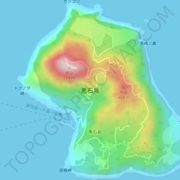
Name: Akusekijima topographic map, elevation, terrain.
Average elevation: 112 m
Minimum elevation: -1 m
Maximum elevation: 556 m
Make a donation
Gear up for your next adventure:
As an Amazon Associate, this site earns from qualifying purchases at no extra cost to you.