Geolocate

Hilliard topographic map

Click on the map to display elevation.

About this map
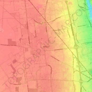
Name: Hilliard topographic map, elevation, terrain.

Location: Hilliard, Norwich Township, Franklin County, Ohio, United States (39.99959 -83.21408 40.06913 -83.09720)

Average elevation: 279 m

Minimum elevation: 216 m

Maximum elevation: 293 m

Other topographic maps

Click on a map to view its topography, its elevation and its terrain.
Columbus

United States > Ohio > Franklin County > Columbus

The confluence of the Scioto and Olentangy rivers is just north-west of Downtown Columbus. Several smaller tributaries course through the Columbus metropolitan area, including Alum Creek, Big Walnut Creek, and Darby Creek. Columbus is considered to have relatively flat topography thanks to a large glacier that…

Average elevation: 255 m

Galloway

United States > Ohio > Franklin County

Average elevation: 276 m

Roseland

United States > Ohio > Franklin County > Columbus

Average elevation: 245 m

Blacklick

United States > Ohio > Franklin County

Average elevation: 288 m

Flint

United States > Ohio > Franklin County

Average elevation: 279 m

Sandy Corners

United States > Ohio > Franklin County > Dublin

Average elevation: 282 m

Mifflinville

United States > Ohio > Franklin County

Average elevation: 259 m

Briarcliff

United States > Ohio > Franklin County > Reynoldsburg

Average elevation: 270 m

Havens Corners

United States > Ohio > Franklin County

Average elevation: 296 m

Shepard

United States > Ohio > Franklin County > Columbus

Average elevation: 245 m

Wrexham Park

United States > Ohio > Franklin County > Columbus

Average elevation: 234 m

Bexley

United States > Ohio > Franklin County > Bexley > Bexley

Average elevation: 243 m

Unique Tree

United States > Ohio > Franklin County

Average elevation: 272 m

Gear up for your next adventure:

🧊Personal Water Filters - Drink safely from mountain streams marked on your map
🥤Hydration Bladders - Hands-free hydration systems for backpacks
📕Outdoor Navigation Books - Learn traditional and modern navigation techniques
🔥Emergency Fire Starters - Reliable ignition tools for survival situations in damp conditions
🧣Neck Gaiters - Protects against wind and sun on exposed ridges and peaks

As an Amazon Associate, this site earns from qualifying purchases at no extra cost to you.