
Wolcottville topographic map
Interactive map
Click on the map to display elevation.
About this map
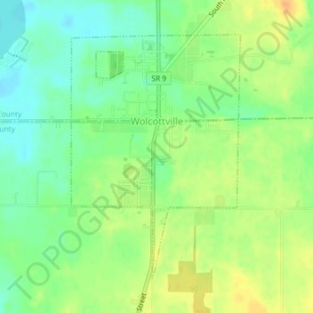
Name: Wolcottville topographic map, elevation, terrain.
Location: Wolcottville, Noble County, Indiana, United States (41.51232 -85.37652 41.53336 -85.35702)
Average elevation: 287 m
Minimum elevation: 270 m
Maximum elevation: 305 m
Other topographic maps
Click on a map to view its topography, its elevation and its terrain.
Chain O'Lakes State Park
United States > Indiana > Noble County
Chain O'Lakes State Park, 9, Noble County, Indiana, United States
Average elevation: 290 m
Avilla
United States > Indiana > Noble County
Avilla, Noble County, Indiana, United States
Average elevation: 294 m
Kendallville
United States > Indiana > Noble County
Kendallville, Noble County, Indiana, 46755, United States
Average elevation: 303 m
Albion
United States > Indiana > Noble County
Albion, Noble County, Indiana, United States
Average elevation: 285 m
Ligonier
United States > Indiana > Noble County
Ligonier, Noble County, Indiana, United States
Average elevation: 277 m
Kendallville
United States > Indiana > Noble County > Kendallville > Kendallville
Kendallville, Noble County, Indiana, 46755, United States
Average elevation: 304 m