
Make a donation
Gear up for your next adventure:
As an Amazon Associate, this site earns from qualifying purchases at no extra cost to you.
Harleston topographic map
Click on the map to display elevation.
Make a donation
Gear up for your next adventure:
As an Amazon Associate, this site earns from qualifying purchases at no extra cost to you.
About this map
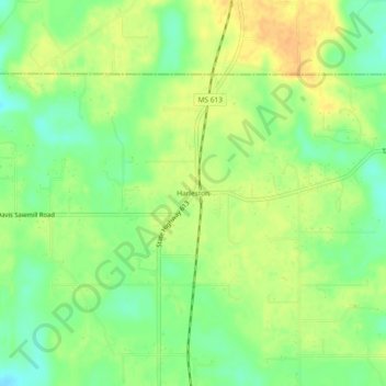
Name: Harleston topographic map, elevation, terrain.
Location: Harleston, Jackson County, Mississippi, United States (30.70269 -88.52891 30.74269 -88.48891)
Average elevation: 36 m
Minimum elevation: 19 m
Maximum elevation: 50 m
Make a donation
Gear up for your next adventure:
As an Amazon Associate, this site earns from qualifying purchases at no extra cost to you.
Other topographic maps
Click on a map to view its topography, its elevation and its terrain.
Make a donation
Gear up for your next adventure:
As an Amazon Associate, this site earns from qualifying purchases at no extra cost to you.
Gulf Hills
United States > Mississippi > Jackson County
The terrain in the Bayou Porteaux region is relatively high considering its proximity to the Gulf of Mexico. Elevations range from sea level to 25 feet (7.6 m) above sea level. The area of interest lies south of the Big Ridge escarpment, on the western terminus of an east-west striking coastal ridge, which is…
Average elevation: 8 m
Make a donation
Gear up for your next adventure:
As an Amazon Associate, this site earns from qualifying purchases at no extra cost to you.
Make a donation
Gear up for your next adventure:
As an Amazon Associate, this site earns from qualifying purchases at no extra cost to you.