Geolocate

Beura-Cardezza topographic map

Click on the map to display elevation.

About this map

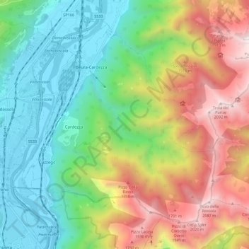
Name: Beura-Cardezza topographic map, elevation, terrain.

Location: Beura-Cardezza, Verbano-Cusio-Ossola, Piedmont, 28851, Italy (46.03094 8.26900 46.09282 8.37905)

Average elevation: 937 m

Minimum elevation: 221 m

Maximum elevation: 2,126 m

Other topographic maps

Click on a map to view its topography, its elevation and its terrain.

Zoverallo

Italy > Piedmont > Verbano-Cusio-Ossola > Verbania

Average elevation: 322 m

Cascata

Italy > Piedmont > Verbano-Cusio-Ossola > Formazza

Average elevation: 1,990 m

Castello

Italy > Piedmont > Verbano-Cusio-Ossola > Varzo

Average elevation: 978 m

Prà della Marta

Italy > Piedmont > Verbano-Cusio-Ossola > Brolo

Average elevation: 491 m

Cireggio

Italy > Piedmont > Verbano-Cusio-Ossola > Omegna

Average elevation: 514 m

Mottarone

Italy > Piedmont > Verbano-Cusio-Ossola > Stresa

Mottarone is a mountain in the Western Alps of Piedmont, north-western Italy, with an elevation of 1,492 metres (4,895 ft). It is located between the provinces of Verbano-Cusio-Ossola and Novara.

Average elevation: 1,177 m

Pianezza

Italy > Piedmont > Verbano-Cusio-Ossola > Bolco

Average elevation: 615 m

Prati

Italy > Piedmont > Verbano-Cusio-Ossola > Macugnaga

Average elevation: 1,809 m

Quarazza

Italy > Piedmont > Verbano-Cusio-Ossola > Macugnaga

Average elevation: 1,665 m

Solivo

Italy > Piedmont > Verbano-Cusio-Ossola > Cannobio

Average elevation: 383 m

Pianezza

Italy > Piedmont > Verbano-Cusio-Ossola > San Carlo

Average elevation: 1,064 m

Iselle

Italy > Piedmont > Verbano-Cusio-Ossola > Trasquera

Average elevation: 1,347 m

Carcioni

Italy > Piedmont > Verbano-Cusio-Ossola

Average elevation: 338 m

Oggiogno

Italy > Piedmont > Verbano-Cusio-Ossola

Average elevation: 573 m

Borca

Italy > Piedmont > Verbano-Cusio-Ossola > Omegna

Average elevation: 510 m

Gear up for your next adventure:

🧊Personal Water Filters - Drink safely from mountain streams marked on your map
🖼️Topographic Map Art - Decorative 3D-effect posters of famous UK peaks and regions
🧴Tick Removal Tools - Small, essential health tool for UK woodland and moorland
🥾Men's Waterproof Hiking Boots - Durable footwear with deep lugs for muddy and rocky UK terrains
📸Action Camera Chest Mounts - Record your ascent following topographic paths hands-free

As an Amazon Associate, this site earns from qualifying purchases at no extra cost to you.