
Mamberamo River topographic map
Interactive map
Click on the map to display elevation.
About this map
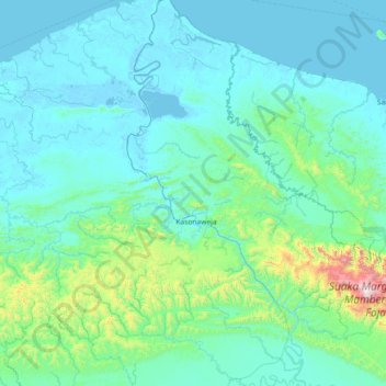
Name: Mamberamo River topographic map, elevation, terrain.
Location: Mamberamo River, Papua, Western New Guinea, Indonesia (-2.92501 137.77220 -1.47371 138.44196)
Average elevation: 172 m
Minimum elevation: -3 m
Maximum elevation: 2,190 m
Other topographic maps
Click on a map to view its topography, its elevation and its terrain.