Geolocate

Divlia topographic map

Interactive map

Click on the map to display elevation.

About this map

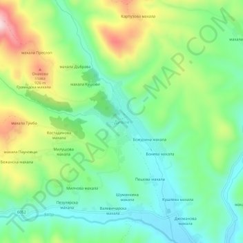
Name: Divlia topographic map, elevation, terrain.

Location: Divlia, Zemen, Pernik, 2456, Bulgaria (42.56269 22.66933 42.60269 22.70933)

Average elevation: 769 m

Minimum elevation: 653 m

Maximum elevation: 997 m

Other topographic maps

Click on a map to view its topography, its elevation and its terrain.

Gorna Dikanya

Bulgaria > Pernik

Average elevation: 801 m

Tran

Bulgaria > Pernik

Average elevation: 872 m

Конска

Bulgaria > Pernik > Sopitsa

Average elevation: 774 m

Vitosha

Bulgaria > Pernik

Due to a great variability in elevation, a rich diversity of climates, flora and fauna can be found within the park. Research has revealed that on the comparatively small area of the mountain there are 1,500 species of higher plants, 500 species of fungi, 500 species of algae, 326 species of mosses, and 200…

Average elevation: 2,105 m

Kalishte

Bulgaria > Pernik

Average elevation: 661 m

Bankya

Bulgaria > Pernik

Average elevation: 836 m

Divotino

Bulgaria > Pernik

Average elevation: 822 m

Dragomirovo

Bulgaria > Pernik

Average elevation: 926 m

Bosnek

Bulgaria > Pernik

Average elevation: 1,017 m