Ghermănești topographic map
Interactive map
Click on the map to display elevation.
About this map
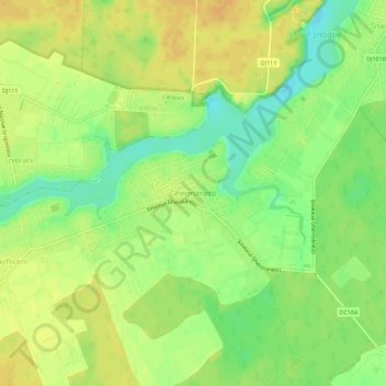
Name: Ghermănești topographic map, elevation, terrain.
Location: Ghermănești, Snagov, Ilfov, 77170, Romania (44.67014 26.12507 44.71014 26.16507)
Average elevation: 94 m
Minimum elevation: 77 m
Maximum elevation: 105 m
Other topographic maps
Click on a map to view its topography, its elevation and its terrain.
Popești-Leordeni
Romania > Ilfov > Popești-Leordeni
Popești-Leordeni, Ilfov, Romania
Average elevation: 71 m
Ștefăneștii de Jos
Romania > Ilfov > Ștefăneștii de Jos
Ștefăneștii de Jos, Ilfov, 77175, Romania
Average elevation: 85 m
Moara Vlăsiei
Romania > Ilfov > Moara Vlăsiei
Moara Vlăsiei, Ilfov, 77130, Romania
Average elevation: 87 m
Petrăchioaia
Romania > Ilfov > Petrăchioaia
Petrăchioaia, Ilfov, 77155, Romania
Average elevation: 80 m