
Puerto Barrios topographic map
Interactive map
Click on the map to display elevation.
Puerto Barrios
The municipality's elevation varies from level at Punta de Manabique to 1,276 metres or 4,186 feet above sea level at Cerro San Gil. The municipal capital is located on the shore of Santo Tomás internal bay, which is part of Amatique Bay. There is a small peninsula called Punta de Manabique which separates the small bay from the Gulf of Honduras, and shelters it from storms.
About this map
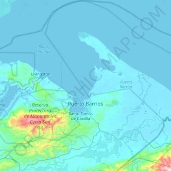
Name: Puerto Barrios topographic map, elevation, terrain.
Location: Puerto Barrios, Izabal, Guatemala (15.50177 -88.74738 16.07236 -88.21344)
Average elevation: 78 m
Minimum elevation: -4 m
Maximum elevation: 1,527 m
Other topographic maps
Click on a map to view its topography, its elevation and its terrain.